The Colorado River winds its way through the Southwestern United States, ending in northern Mexico. Beginning in the Colorado Rockies, it flows through the Colorado Plateau. The plateau created the Grand Canyon. The river pauses at Lake Mead before turning south and heading for the border. Along its path in the United States, the iconic river passes through whitewater rapids, 11 national parks, several state parks, and numerous canyons. It is part of a system that is a “vital source of water for 40 million people.”
The Course of the Colorado River
You can follow the course of the Colorado River from its source to Mexico. It’s a scenic route through several U.S. states to the Hoover Dam, and into Mexico.
Through Colorado
Beginning its run in the state of Colorado, the Colorado River winds slowly down through the Rocky Mountains. It begins as a tiny stream originating from not much more than a wet meadow in Rocky Mountain National Park. It is an integral part of the Continental Divide that separates the watersheds of the Pacific Ocean and the Gulf of Mexico.
Several smaller tributaries join forces with the mighty river before it flows through Gore Canyon, where enthusiasts enjoy whitewater rafting. Ranging from 200 to 1,200 feet wide, the river depth averages 6 to 30 feet deep with occasional sections of deeper water.
Through Utah
The Colorado River runs northwest for a short span before it turns southwest again right before it enters Utah. It enters the Colorado Plateau, then travels through Westwater Canyon. Picking up more water from the Dolores River and the San Miguel river, it becomes the southern border of the Arches National Park. South of the Moab Valley, the river has carved out a mountain pass known as “The Portal.”
It passes through Dead Horse State Park and Canyonlands National Park. With water supplied by the Wind River Range of western Wyoming, the Green River is its largest tributary along the route. More small tributaries join in as the Colorado River flows through miles and miles of recreational areas. A pause at the reservoir formed by the Glen Canyon Dam, Lake Powell is the focal point of the Glen Canyon Recreation Area.
Arizona, Nevada, and all points south
The Glen Canyon Dam serves as a hydroelectric power generator. When the waters leave Lake Powell, they flow through Glen Canyon, then through the beautiful Horseshoe Bend (pictured above).
Perhaps the most well-known feature of the Colorado River in the Grand Canyon, which winds through northern Arizona. It is joined by smaller tributaries as the water flows through the canyon. The force of the channeled water creates violent rapids, calm pools, and everything in between. The Grand Canyon is 217 miles long with walls reaching from 4,000 to 6,000 feet high.
As the water from the river leaves the Grand Canyon at Grand Wash Cliffs, it gets corralled by the Hoover Dam and widens to form the reservoir known as Lake Mead. The river at this point forms a non-specific boundary between the Colorado Plateau and the Mojave Desert. From this point, the river flows along the lines between the states of Nevada-Arizona and California-Arizona until it reaches Mexico.
Following the Colorado River map
There is no shortage of scenic stops along the length of the Colorado River. Visitors can view the river from roadways via automobiles and train tracks via Amtrak passenger trains. State and national parks dot the landscape along her route. More than 2 million people a year visit the remote location surrounding the Lake Powell reservoir.
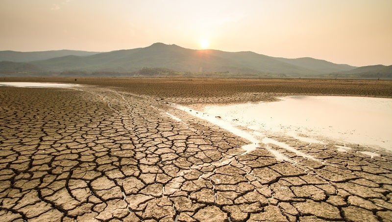
Effects of Climate Change on Colorado River Flows
The worst drought in history since 1906 was the period between 2000 and 2014. This period saw an average decrease of 19 percent in the rate of flow along the mighty Colorado River. What makes this concerning is higher overall temperatures in recent years.
Temperatures recorded in the Upper Basin averaged 1.6 degrees Fahrenheit higher during the 2000 – 2014 period. The Upper Basin is where most runoff is produced that feeds the river. The phenomenon is known as a “hot drought.” The higher temperatures have continued in 2015 and 2016. Runoff was greater in 2017, but it wasn’t enough to restore reservoir levels.
The effect of higher temperatures on the river isn’t immediately noticeable but has a cumulative effect that can be devastating. Higher temperatures cause the snow that supplies much of the river’s runoff water supply to melt earlier. This leads to a longer growing season for plants and vegetation. That increases the water demand from surrounding fauna, further depleting the water supplies.
Evaporation increases from the river and soil. Coupled with the daily increase in plant water usage. The higher temperatures mean that the atmosphere is drawing more water and that causes less water to be available to the river. Evaporation increases at a rate of about 4 percent for every added degree of temperature (Fahrenheit).
Follow the length of the Colorado River in this video produced by Denver7 (It is almost 22 minutes long, but worth the time):
Lake Mead Water Level
The water level in both the Lake Powell and Lake Mead reservoirs are being used to gauge how dire the situation of global climate change is. The last time Lake Mead was considered “at full capacity” was in 1983.
Lake Mead is a reservoir that is meant to fluctuate. Over the past 80-plus years, its capacity has varied greatly. Storing more than 3 trillion gallons of water, Lake Mead is currently at 39 percent capacity, so it’s lost nearly two-thirds of its stored water in the past 35 years. However, the demand for water has continued to rise due to growing populations and the need for increased irrigation during the drought of the past 15 years. Many states, cities, and organizations are working hard to increase conservation efforts to help balance out the supply and demand.
You can easily measure the Lake Mead level with the naked eye by viewing the “bathtub ring” that surrounds the lake at its optimal water level. While not accurate to the gallon, it provides a quick and ready reference to point out the damage of climate change on the water supply. Public information officer at Lake Mead Recreational Area, Christie Vanover, uses the ring to describe the Lake Mead water level:
The top of the white ring is about 140 feet above the current lake elevation.
How this affects the Colorado River
Through a system of reservoirs, aqueducts, and dams, the river provides hydroelectric power, irrigation, and drinking water. Because of this extensive usage, much of the last 100 miles of the river has dried up. The Colorado River flows have rarely reached as far south as the sea since the 1960s. The Colorado River Delta in Mexico where the river meets the Gulf of Mexico between Baja California in Mexico and Sonora is mostly dry.
Outlook for Lake Meade water level into the future
When it is completely full, Lake Mead water is 1,220 feet above sea level. In 2022, it rose from 1,075 to 1.082 feet. While that is good news for the entire area, it does not mean an end to the level of concern. If the water level drops below 1,075 feet, it may cause water shortage situations in three states (Arizona, California, and Nevada) and Mexico. A drop to 1,000 feet would be dire.
The Importance of Water to our Eco-System
Water is life. Twenty percent of the world’s water supply is tied up in the Great Lakes surrounding the state of Michigan. Snow-melt runoff must replenish other sources such as the Colorado River. Preserving this finite resource and maintaining systems that keep freshwater sources clean is integral to our survival.
The Southern Nevada Water Authority has started some work on preserving a water supply for Las Vegas. They have installed a sort of “straw” under Lake Mead connected to an intake structure miles from the lake. In the event that water levels decrease below the 1,000-foot mark, Las Vegas will be able to utilize this “straw” to draw water out of the lake. But that won’t help replenish the water supply. It will only deplete it further.
While there is no shortage of water in the west projected for 2022, concern must stay at the forefront of water conservation projects stretching into the future.
Many rivers in the American Southwest are affected by global climate change and increased temperatures. The Rio Grande, which flows along the border between Texas and Mexico is also greatly affected. The Great Lakes, Mississippi River, Ohio River, and other water sources in the Midwest are also suffering.
Clean, freshwater is a finite resource. Once it is gone, we can’t magically make more.
-
Although disproved, the notion of a “climate change hiatus” is one that perpetuates in the…
-
The Arctic Shelf. Areas on our planet are defined by extremes. They represent the harsh…
-
Fossil fuels produce electricity, run car engines, make plastics, and power mills, factories, and industries.…
-
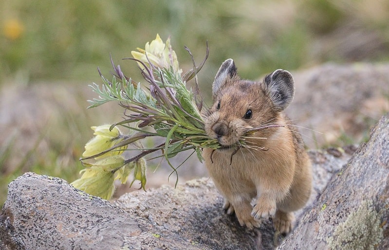
The pika may be the next victim of climate change. Like animals across the globe,…
-
Oxygen is one of the most precious elements on Earth. Humans, plants, animals, and just…
-
If you pay any attention to the impact climate change is having on our planet,…
-
Methane gas is found in landfills, manure, and wetlands. Both natural and man-made activities produce…
-
Some people have proposed carbon sequestration as a solution to global climate change. But what…

